Belfast Peacelines
3.1.1 Reference code(s)
UK INT-ARC PA2015 CL00-MA014
3.1.2 Title
Belfast Peacelines
3.1.3 Location
Falls - Shankill, Belfast
3.1.4 Owner
Map drawn by James O'Leary in 2015, based on map produced for: Cosstick, V. (2015). Belfast: Toward a City without walls. Belfast: Colourpoint.
3.1.5 Year
2015
3.1.6 Type
Map of extent of Belfast Peacelines in relation to City Centre and River Lagan, mapped in 2015
3.2.1 Date of description
2017
3.2.2 Level of description
Items
3.2.3 Extent and Medium
Digital Image - 2144 × 1424 pixels JPEG Image
3.2.4 Name of creator(s)
© James O'Leary / Interface Architecture
3.2.5 Archival History
Archived on May 25, 2017
3.4.1 Conditions of access
No restrictions on access. Reproduction requires permission.

Belfast Areas Map
3.1.1 Reference code(s)
UK INT-ARC PA2015 CL00-MA001
3.1.2 Title
Belfast Areas Map
3.1.3 Location
Belfast City Centre and Outskirts
3.1.4 Owner
Unknown
3.1.5 Year
Unknown(c. 1970s?)
3.1.6 Type
Map of Belfast on card, constructed from insulation tape, vinyl text and colour transfers
3.2.1 Date of description
2017
3.2.2 Level of description
Items
3.2.3 Extent and Medium
Digital Image - 2144 × 1424 pixels JPEG Image
3.2.4 Name of creator(s)
© Unknown - If you know the owner please contact curator@peacewall-archive.net
3.2.5 Archival History
Archived on May 25, 2017
3.4.1 Conditions of access
No restrictions on access. Reproduction requires permission.

Belfast Riots Map 1857-1980
3.1.1 Reference code(s)
UK INT-ARC PA2015 CL00-MA002
3.1.2 Title
Belfast Riots Map
3.1.3 Location
Belfast City Centre and Outskirts
3.1.4 Owner
Sourced from The Troubles, Taylor Downing (ed), Thames & Hudson, 1980
3.1.5 Year
1980
3.1.6 Type
Map of Belfast riot locations 1857-1980
3.2.1 Date of description
2017
3.2.2 Level of description
Items
3.2.3 Extent and Medium
Digital Image - 2144 × 1424 pixels JPEG Image
3.2.4 Name of creator(s)
© Thames & Hudson
3.2.5 Archival History
Archived on May 25, 2017
3.4.1 Conditions of access
No restrictions on access. Reproduction requires permission.

Religious Distribution in Belfast
3.1.1 Reference code(s)
UK INT-ARC PA2015 CL00-MA005
3.1.2 Title
Map of Religious Distribution in Belfast
3.1.3 Location
Belfast City Centre and Environs
3.1.4 Owner
Sourced from IrelandStory.com Website
3.1.5 Year
1991
3.1.6 Type
Map of Religious Distribution in Belfast, mapped from Census Information, 1991
3.2.1 Date of description
2017
3.2.2 Level of description
Items
3.2.3 Extent and Medium
Digital Image - 2144 × 1424 pixels JPEG Image
3.2.4 Name of creator(s)
© IrelandStory.com
3.2.5 Archival History
Archived on May 25, 2017
3.4.1 Conditions of access
No restrictions on access. Reproduction requires permission.

Spending Behaviour Analysis Map
3.1.1 Reference code(s)
UK INT-ARC PA2015 CL00-MA003
3.1.2 Title
Belfast Spending Behaviour Analysis Map
3.1.3 Location
Cupar area, between Falls & Shankill, Belfast
3.1.4 Owner
Sourced from Boal, F.W. (1969) Territoriality on the Shankill–Falls Divide, Belfast. Irish Geography, 6: 30–50.
3.1.5 Year
Analysis conducted in 1968, Published in 1969
3.1.6 Type
Map of Spending Behaviour at Cupar, Belfast, 1968
3.2.1 Date of description
2017
3.2.2 Level of description
Items
3.2.3 Extent and Medium
Digital Image - 2144 × 1424 pixels JPEG Image
3.2.4 Name of creator(s)
© F.Boal
3.2.5 Archival History
Archived on May 25, 2017
3.4.1 Conditions of access
No restrictions on access. Reproduction requires permission.
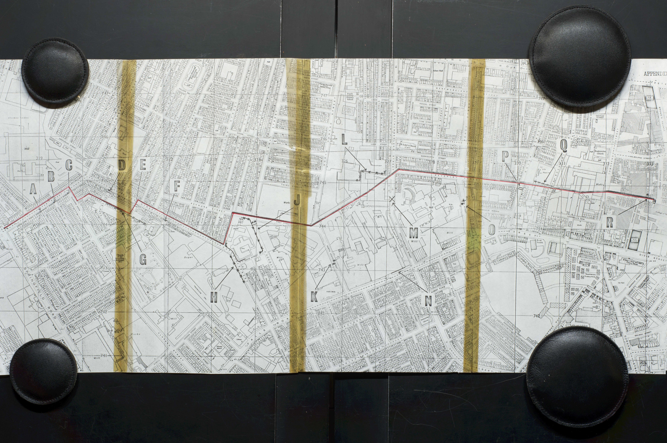
Taylor Report, Appendix B (i) Map of Falls - Shankill Peaceline, 1971
3.1.1 Reference code(s)
UK INT-ARC PA2015 CL00-MA004
3.1.2 Title
Map of Falls - Shankill Peaceline in 1971
3.1.3 Location
Falls / Shankill Interface, Belfast
3.1.4 Owner
Sourced from Taylor, J. (1971) ‘FUTURE POLICY ON AREAS OF CONFRONTATION’ Second (and final) Report of the Joint Working Party on Processions, etc, Appendix B (i), (1971 PRONI:CAB/1634/3)
3.1.5 Year
1971
3.1.6 Type
Map of first Belfast Peaceline in 1971
3.2.1 Date of description
2017
3.2.2 Level of description
Items
3.2.3 Extent and Medium
Digital Image - 2144 × 1424 pixels JPEG Image
3.2.4 Name of creator(s)
© PRONI
3.2.5 Archival History
Archived on May 25, 2017
3.4.1 Conditions of access
No restrictions on access. Reproduction requires permission.

Number of people killed due to the conflict in Belfast, 1969-2001
3.1.1 Reference code(s)
UK INT-ARC PA2015 CL00-MA006
3.1.2 Title
Number of people killed due to the conflict in Belfast between 1969-2001
3.1.3 Location
Belfast City Centre and Environs
3.1.4 Owner
Map produced by CAIN Webservice
3.1.5 Year
2001
3.1.6 Type
Location map of people killed due to the conflict in Belfast between 1969-2001
3.2.1 Date of description
2017
3.2.2 Level of description
Items
3.2.3 Extent and Medium
Digital Image - 2144 × 1424 pixels JPEG Image
3.2.4 Name of creator(s)
© CAIN @Ulster University
3.2.5 Archival History
Archived on May 25, 2017
3.4.1 Conditions of access
No restrictions on access. Reproduction requires permission.

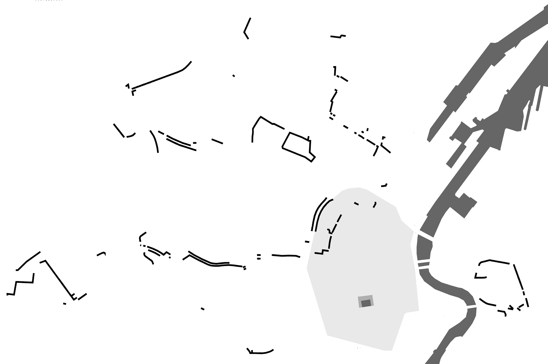
Falls - Shankill Peaceline
3.1.1 Reference code(s)
UK INT-ARC PA2015 CL00-MA013
3.1.2 Title
Falls - Shankill Peaceline in Belfast
3.1.3 Location
Falls - Shankill, Belfast
3.1.4 Owner
Map produced by James O'Leary during field research in 2015, against an aerial photography courtesy of Google Maps.
3.1.5 Year
2015
3.1.6 Type
Map of extent of Falls - Shankill Peaceline, mapped in 2015
3.2.1 Date of description
2017
3.2.2 Level of description
Items
3.2.3 Extent and Medium
Digital Image - 2144 × 1424 pixels JPEG Image
3.2.4 Name of creator(s)
© James O'Leary / Interface Architecture
3.2.5 Archival History
Archived on May 25, 2017
3.4.1 Conditions of access
No restrictions on access. Reproduction requires permission.

Deaths due to the conflict in Belfast, 1969-2001
3.1.1 Reference code(s)
UK INT-ARC PA2015 CL00-MA007
3.1.2 Title
Deaths due to the conflict in Belfast between 1969-2001
3.1.3 Location
Belfast City Centre and Environs
3.1.4 Owner
Map produced by CAIN Webservice
3.1.5 Year
2001
3.1.6 Type
Map of Deaths due to the conflict in Belfast between 1969-2001
3.2.1 Date of description
2017
3.2.2 Level of description
Items
3.2.3 Extent and Medium
Digital Image - 2144 × 1424 pixels JPEG Image
3.2.4 Name of creator(s)
© CAIN @Ulster University
3.2.5 Archival History
Archived on May 25, 2017
3.4.1 Conditions of access
No restrictions on access. Reproduction requires permission.

Physical Memorials related to the conflict in Belfast area
3.1.1 Reference code(s)
UK INT-ARC PA2015 CL00-MA008
3.1.2 Title
Physical Memorials related to the conflict in Belfast area (2010)
3.1.3 Location
Belfast City Centre and Environs
3.1.4 Owner
Map produced by CAIN Webservice
3.1.5 Year
2001
3.1.6 Type
Map of Physical Memorials related to the conflict in Belfast area (2010) and Northern Ireland Multiple Deprivation Measure score (2005) at ward level.
3.2.1 Date of description
2017
3.2.2 Level of description
Items
3.2.3 Extent and Medium
Digital Image - 2144 × 1424 pixels JPEG Image
3.2.4 Name of creator(s)
© CAIN @Ulster University
3.2.5 Archival History
Archived on May 25, 2017
3.4.1 Conditions of access
No restrictions on access. Reproduction requires permission.

Deaths prior and after the establishment of Lanark Way Peaceline
3.1.1 Reference code(s)
UK INT-ARC PA2015 CL00-MA009
3.1.2 Title
Deaths due to the conflict prior and after the establishment of the Lanark Way Peaceline in Belfast in 1988
3.1.3 Location
Belfast City Centre and Environs
3.1.4 Owner
Map produced by CAIN Webservice
3.1.5 Year
2001
3.1.6 Type
Map of deaths to the conflict, in two three-year periods prior to (1985-1987) and after (1989-1991) the establishment of the Lanark Way Peaceline (in 1988) in Belfast, and distribution of Catholics of adjoining wards in Belfast (2001).
3.2.1 Date of description
2017
3.2.2 Level of description
Items
3.2.3 Extent and Medium
Digital Image - 2144 × 1424 pixels JPEG Image
3.2.4 Name of creator(s)
© CAIN @Ulster University
3.2.5 Archival History
Archived on May 25, 2017
3.4.1 Conditions of access
No restrictions on access. Reproduction requires permission.

Peacewall Conditions Map
3.1.1 Reference code(s)
UK INT-ARC PA2015 CL00-MA010
3.1.2 Title
Map of Peacewall Conditions at Falls - Shankill Interface
3.1.3 Location
Falls - Shankill Interface
3.1.4 Owner
Paul Bower
3.1.5 Year
2006
3.1.6 Type
Map and Cross-Sections from 'Reprogramming the Wall' Project, conducted as part of 5th Year thesis, Masters of Architecture, University of Sheffield, Sheffield School of Architecture (SSoA), Year: 2005/6
3.2.1 Date of description
2017
3.2.2 Level of description
Items
3.2.3 Extent and Medium
Digital Image - 2144 × 1424 pixels JPEG Image
3.2.4 Name of creator(s)
© Paul Bower
3.2.5 Archival History
Archived on May 25, 2017
3.4.1 Conditions of access
No restrictions on access. Reproduction requires permission.
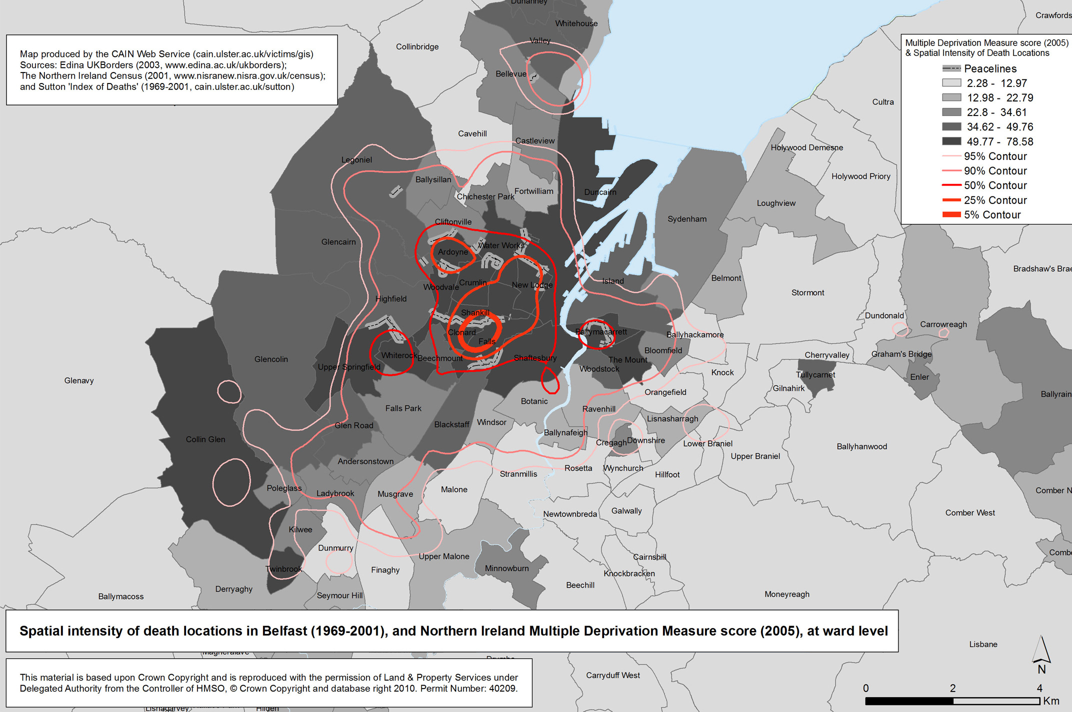
Spatial Intensity of Death Location in Belfast (1969-2001)
3.1.1 Reference code(s)
UK INT-ARC PA2015 CL00-MA011
3.1.2 Title
Spatial Intensity of death locations in Belfast area (1969-2001)
3.1.3 Location
Belfast City Centre and Environs
3.1.4 Owner
Map produced by CAIN Webservice
3.1.5 Year
2010
3.1.6 Type
Map of spatial intensity of death locations in Belfast area (1969-2001) and Northern Ireland Multiple Deprivation Measure score (2005) at ward level.
3.2.1 Date of description
2017
3.2.2 Level of description
Items
3.2.3 Extent and Medium
Digital Image - 2144 × 1424 pixels JPEG Image
3.2.4 Name of creator(s)
© CAIN @Ulster University
3.2.5 Archival History
Archived on May 25, 2017
3.4.1 Conditions of access
No restrictions on access. Reproduction requires permission.

Peacelines, Deaths & Deprivation in Belfast
3.1.1 Reference code(s)
UK INT-ARC PA2015 CL00-MA012
3.1.2 Title
Peacelines, deprivation and segregation densities of fatal violence in Belfast
3.1.3 Location
Belfast City Centre and Environs
3.1.4 Owner
Map produced by Cunningham & Gregory for:
Hard to miss, easy to blame? : peacelines, interfaces and political deaths in Belfast during the Troubles. / Cunningham, Niall; Gregory, Ian.
In: Political Geography, Vol. 40, 05.2014, p. 64-78.
3.1.5 Year
2010
3.1.6 Type
Map of Peacelines, inter-quartile ranges of densities of conflict deaths and bivariate LISA analysis of deprivation and religio-political segregation in Belfast at 100 m2, mapped in 2014
3.2.1 Date of description
2017
3.2.2 Level of description
Items
3.2.3 Extent and Medium
Digital Image - 2144 × 1424 pixels JPEG Image
3.2.4 Name of creator(s)
© Cunningham & Gregory
3.2.5 Archival History
Archived on May 25, 2017
3.4.1 Conditions of access
No restrictions on access. Reproduction requires permission.

Belfast Peacewall Clusters
3.1.1 Reference code(s)
UK INT-ARC PA2015 CL00-MA015
3.1.2 Title
Belfast Peacewall Clusters
3.1.3 Location
Belfast
3.1.4 Owner
Map constructed by Bob Harper / OpenData in 2017, based on fieldwork and research by Jarman / iCR and Belfast Interface Project
3.1.5 Year
2017
3.1.6 Type
Interactive Map of clusters of Belfast Peacelines in relation to City Centre using @CARTO, mapped in 2017
3.2.1 Date of description
2017
3.2.2 Level of description
Items
3.2.3 Extent and Medium
Digital Image - 2144 × 1424 pixels JPEG Image
3.2.4 Name of creator(s)
© Belfast Interface Project / iCR / TheDetail
3.2.5 Archival History
Archived on May 25, 2017
3.4.1 Conditions of access
No restrictions on access. Reproduction requires permission.
Maps