
1922 Newtownards Road & Seaforde Street
3.1.1 Reference code(s)
UK INT-ARC PA2015 CL12-P0100
3.1.2 Title
Photograph of Interface Barrier under construction at Newtownards Road, at the junction with Seaforde Street, Belfast. c. 1922
3.1.3 Cluster
BIP Interface Cluster 12: Short Strand / Inner East
3.1.4 Owner
None. Structure no longer in existence.
3.1.5 Year built:
c.1922
3.1.6 Type
Boarded Timber Frame Construction, c. 4m high
3.2.1 Date of description
2017
3.2.2 Level of description
Items
3.2.3 Extent and Medium
Digital Image - 1529 × 1159 pixels JPEG Image
3.2.4 Name of creator(s)
© Unknown - If you know the owner/photographer please contact curator@peacewall-archive.net
3.2.5 Archival History
Archived on January 24, 2017
3.4.1 Conditions of access
No restrictions on access. Reproduction requires permission.

1969 Kashmir Road / Bombay Steet
3.1.1 Reference code(s)
UK INT-ARC PA2015 CL03-P0100
3.1.2 Title
Photograph of newly constructed Barricade at junction of Kashmir Road and Bombay Street, Belfast. 1969
3.1.3 Cluster
BIP Interface Cluster 03: Falls / Shankill
3.1.4 Owner
No longer in existence. Replaced by later Cupar Street 'Peaceline'.
3.1.5 Year built:
1969
3.1.6 Type
Trailer, Car, Metal sheets, Metal objects, Debris.
3.2.1 Date of description
2017
3.2.2 Level of description
Items
3.2.3 Extent and Medium
Digital Image - 2144 × 1424 pixels JPEG Image
3.2.4 Name of creator(s)
© Unknown - If you know the owner/photographer please contact curator@peacewall-archive.net
3.2.5 Archival History
Archived on January 24, 2017
3.4.1 Conditions of access
No restrictions on access. Reproduction requires permission.

1969 Coates Street
3.1.1 Reference code(s)
UK INT-ARC PA2015 CL03-P0100
3.1.2 Title
Photograph of Barricade under construction at Coates Street, Belfast 1969.
This is reported to be the first part of the Falls/Shankill 'Peaceline' constructed in Belfast.
3.1.3 Cluster
BIP Interface Cluster 03: Falls / Shankill
3.1.4 Owner
No longer in existence. Removed during construction of Westlink.
3.1.5 Year built:
1969
3.1.6 Type
Corrugated Metal Sheets, on subframe.
3.2.1 Date of description
2017
3.2.2 Level of description
Items
3.2.3 Extent and Medium
Digital Image - 2144 × 1424 pixels JPEG Image
3.2.4 Name of creator(s)
© Unknown - If you know the owner/photographer please contact curator@peacewall-archive.net
3.2.5 Archival History
Archived on January 25, 2017
3.4.1 Conditions of access
No restrictions on access. Reproduction requires permission.

1969 Conway Street
3.1.1 Reference code(s)
UK INT-ARC PA2015 CL03-P0100
3.1.2 Title
Photograph of Barricades at Conway Street, Belfast 1969.
3.1.3 Cluster
BIP Interface Cluster 03: Falls / Shankill
3.1.4 Owner
No longer in existence. Barricades were removed and replaced by the first Falls/Shankill Peaceline later in the same year.
3.1.5 Year built:
1969
3.1.6 Type
Debris, Furniture, Building Rubble.
3.2.1 Date of description
2017
3.2.2 Level of description
Items
3.2.3 Extent and Medium
Digital Image - 2144 × 1424 pixels JPEG Image
3.2.4 Name of creator(s)
© Unknown - If you know the owner/photographer please contact curator@peacewall-archive.net
3.2.5 Archival History
Archived on January 25, 2017
3.4.1 Conditions of access
No restrictions on access. Reproduction requires permission.

1969 Cupar Street
3.1.1 Reference code(s)
UK INT-ARC PA2015 CL03-P0100
3.1.2 Title
Photograph of first version of Falls /Shankill 'Peaceline' at Cupar Street, Belfast 1969.
3.1.3 Cluster
BIP Interface Cluster 03: Falls / Shankill
3.1.4 Owner
No longer in existence. Replaced by later structures.
3.1.5 Year built:
1969
3.1.6 Type
Razor Wire coiled around barbed wire fencing supported on metal stanchions.
3.2.1 Date of description
2017
3.2.2 Level of description
Items
3.2.3 Extent and Medium
Digital Image - 2144 × 1424 pixels JPEG Image
3.2.4 Name of creator(s)
© Peter Barzilay
3.2.5 Archival History
Archived on January 25, 2017
3.4.1 Conditions of access
No restrictions on access. Reproduction requires permission.

1969 Leeson Street
3.1.1 Reference code(s)
UK INT-ARC PA2015 CL03-P0100
3.1.2 Title
Photograph of Barricade at Leeson Street at the junction with the Falls Road, Belfast 1969.
This is reported to be the first barricade erected in Belfast in 1969.
3.1.3 Cluster
BIP Interface Cluster 03: Falls / Shankill
3.1.4 Owner
No longer in existence.
3.1.5 Year built:
1969
3.1.6 Type
Stone slabs, metal sheet, debris, furniture, building rubble.
3.2.1 Date of description
2017
3.2.2 Level of description
Items
3.2.3 Extent and Medium
Digital Image - 2144 × 1424 pixels JPEG Image
3.2.4 Name of creator(s)
© Henry V. Bell
3.2.5 Archival History
Archived on January 25, 2017
3.4.1 Conditions of access
No restrictions on access. Reproduction requires permission.

1969 McDonnell Street
3.1.1 Reference code(s)
UK INT-ARC PA2015 CL03-P0100
3.1.2 Title
Photograph of Barricades at McDonnell Street, Belfast 1969.
3.1.3 Cluster
BIP Interface Cluster 03: Falls / Shankill
3.1.4 Owner
No longer in existence. Barricades were removed later in the same year.
3.1.5 Year built:
1969
3.1.6 Type
Timber barrels, timber structures, coiled razor wire
3.2.1 Date of description
2017
3.2.2 Level of description
Items
3.2.3 Extent and Medium
Digital Image - 2144 × 1424 pixels JPEG Image
3.2.4 Name of creator(s)
© Unknown - If you know the owner/photographer please contact curator@peacewall-archive.net
3.2.5 Archival History
Archived on January 25, 2017
3.4.1 Conditions of access
No restrictions on access. Reproduction requires permission.

1969 Percy Street
3.1.1 Reference code(s)
UK INT-ARC PA2015 CL03-P0100
3.1.2 Title
Photograph of Barricades at Percy Street, close to the junction with Beverley Street, Belfast 1969. This photo was taken the day after British Troops arrived in Belfast.
3.1.3 Cluster
BIP Interface Cluster 03: Falls / Shankill
3.1.4 Owner
No longer in existence. Barricades were removed and replaced by the first Falls/Shankill Peaceline later in the same year.
3.1.5 Year built:
1969
3.1.6 Type
Burned out Bus and car, debris, razor wire coiled on timber X-frames.
3.2.1 Date of description
2017
3.2.2 Level of description
Items
3.2.3 Extent and Medium
Digital Image - 2144 × 1424 pixels JPEG Image
3.2.4 Name of creator(s)
© Pepperfoto
3.2.5 Archival History
Archived on January 25, 2017
3.4.1 Conditions of access
No restrictions on access. Reproduction requires permission.
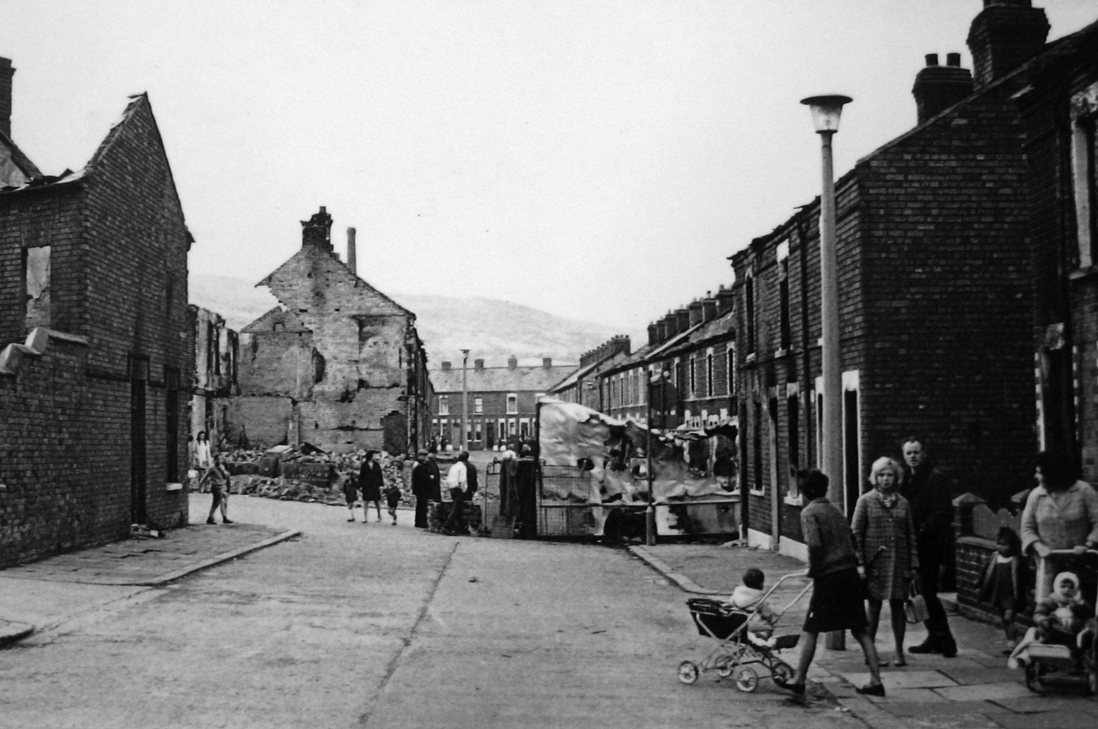
1969 Bombay Street
3.1.1 Reference code(s)
UK INT-ARC PA2015 CL03-P0100
3.1.2 Title
Photograph of Barricade at Bombay Street taken from St. Galls, Belfast 1969.
3.1.3 Cluster
BIP Interface Cluster 03: Falls / Shankill
3.1.4 Owner
No longer in existence. Barricades were removed and replaced by the first Falls/Shankill Peaceline later in the same year.
3.1.5 Year built:
1969
3.1.6 Type
Vehicles, debris, furniture, metal mesh, building rubble.
3.2.1 Date of description
2017
3.2.2 Level of description
Items
3.2.3 Extent and Medium
Digital Image - 2144 × 1424 pixels JPEG Image
3.2.4 Name of creator(s)
© Unknown - If you know the owner/photographer please contact curator@peacewall-archive.net
3.2.5 Archival History
Archived on January 25, 2017
3.4.1 Conditions of access
No restrictions on access. Reproduction requires permission.
1970 Kashmir Road & Bombay Street
3.1.1 Reference code(s)
UK INT-ARC PA2015 CL03-P0100
3.1.2 Title
Photograph of first 'Peaceline' structure at junction of Kashmir Road & Bombay Street, Belfast 1970.
3.1.3 Cluster
BIP Interface Cluster 03: Falls / Shankill
3.1.4 Owner
No longer in existence. This structure was removed and replaced by more significant structures.
3.1.5 Year built:
1970
3.1.6 Type
Corrugated metal sheet on a subframe.
3.2.1 Date of description
2017
3.2.2 Level of description
Items
3.2.3 Extent and Medium
Digital Image - 2144 × 1424 pixels JPEG Image
3.2.4 Name of creator(s)
© Unknown - If you know the owner/photographer please contact curator@peacewall-archive.net
3.2.5 Archival History
Archived on January 25, 2017
3.4.1 Conditions of access
No restrictions on access. Reproduction requires permission.

Belfast Barricades
3.1.1 Reference code(s)
UK INT-ARC PA2015 CL03-P0100
3.1.2 Title
Various Photographs of Barricades and Structures across Belfast 1969.
3.1.3 Cluster
Various
3.1.4 Owner
No longer in existence.
3.1.5 Year built:
1969
3.1.6 Type
Vehicles, debris, furniture, building rubble, barbed wire on X-frames.
3.2.1 Date of description
2017
3.2.2 Level of description
Items
3.2.3 Extent and Medium
Digital Image - 2144 × 1424 pixels JPEG Image
3.2.4 Name of creator(s)
© Belfast Telegraph Photographers
3.2.5 Archival History
Archived on January 25, 2017
3.4.1 Conditions of access
No restrictions on access. Reproduction requires permission.

1979 Cupar Way
3.1.1 Reference code(s)
UK INT-ARC PA2015 CL03-P0100
3.1.2 Title
Photograph of Second Generation Peaceline at Cupar Way from the Clonard side, Belfast 1979.
3.1.3 Cluster
BIP Interface Cluster 03: Falls / Shankill
3.1.4 Owner
No longer in existence. Replaced by more significant structures.
3.1.5 Year built:
1970s
3.1.6 Type
Corrugated metal sheets, scaffold pole supporting structures, supported by concrete base-blocks.
3.2.1 Date of description
2017
3.2.2 Level of description
Items
3.2.3 Extent and Medium
Digital Image - 2144 × 1424 pixels JPEG Image
3.2.4 Name of creator(s)
© Ian Stuttard
3.2.5 Archival History
Archived on January 25, 2017
3.4.1 Conditions of access
No restrictions on access. Reproduction requires permission.
1983 Springfield Road
3.1.1 Reference code(s)
UK INT-ARC PA2015 CL12-P0100
3.1.2 Title
Photograph of New Barnsley defensive barrier constructions at Springfield Road, Belfast. c. 1983
3.1.3 Cluster
BIP Interface Cluster 02: Upper Springfield Road
3.1.4 Owner
Structures no longer in existence. Replaced by 'million brick wall' to New Barnsley PSNI perimeter.
3.1.5 Year built:
1970s/80s
3.1.6 Type
Concrete, steel frame, corrugated metal sheet.
3.2.1 Date of description
2017
3.2.2 Level of description
Items
3.2.3 Extent and Medium
Digital Image - 1529 × 1159 pixels JPEG Image
3.2.4 Name of creator(s)
© Bill Kirk
3.2.5 Archival History
Archived on January 24, 2017
3.4.1 Conditions of access
No restrictions on access. Reproduction requires permission.

1991 North Howard Street
3.1.1 Reference code(s)
UK INT-ARC PA2015 CL03-P0100
3.1.2 Title
Photograph of North Howard Street with Cupar Way beyond, Belfast 1991.
3.1.3 Cluster
BIP Interface Cluster 03: Falls / Shankill
3.1.4 Owner
NI Department of Justice
3.1.5 Year built:
1969 onwards
3.1.6 Type
Concrete, steel frame, corrugated sheet metal.
3.2.1 Date of description
2017
3.2.2 Level of description
Items
3.2.3 Extent and Medium
Digital Image - 2144 × 1424 pixels JPEG Image
3.2.4 Name of creator(s)
© TBC
3.2.5 Archival History
Archived on January 25, 2017
3.4.1 Conditions of access
No restrictions on access. Reproduction requires permission.

1994 St. Galls
3.1.1 Reference code(s)
UK INT-ARC PA2015 CL03-P0100
3.1.2 Title
Photograph of 'Peacewall' at St. Galls, Clonard, Belfast 1980s.
3.1.3 Cluster
BIP Interface Cluster 03: Falls / Shankill
3.1.4 Owner
NI Department of Justice. This structure has since been extended upwards.
3.1.5 Year built:
1969 onwards
3.1.6 Type
Concrete, steel supports, corrugated metal sheet.
3.2.1 Date of description
2017
3.2.2 Level of description
Items
3.2.3 Extent and Medium
Digital Image - 2144 × 1424 pixels JPEG Image
3.2.4 Name of creator(s)
© Frankie Quinn (http://www.frankiequinn.com)
3.2.5 Archival History
Archived on January 25, 2017
3.4.1 Conditions of access
No restrictions on access. Reproduction requires permission.

1991 Cliftonpark Avenue
3.1.1 Reference code(s)
UK INT-ARC PA2015 CL03-P0100
3.1.2 Title
Photograph of burned-out buildings at Cliftonpark Avenue, Belfast 1991.
3.1.3 Cluster
BIP Interface Cluster 08: Lower Oldpark - Manor Street
3.1.4 Owner
No longer in existence. Replaced by later structures which were removed in 2015, to make way for the construction of the current Girdwood Community Hub.
3.1.5 Year built:
1969
3.1.6 Type
Derelict Buildings, brick and corrugated metal structures.
3.2.1 Date of description
2017
3.2.2 Level of description
Items
3.2.3 Extent and Medium
Digital Image - 2144 × 1424 pixels JPEG Image
3.2.4 Name of creator(s)
© Jonathan Olney
3.2.5 Archival History
Archived on January 25, 2017
3.4.1 Conditions of access
No restrictions on access. Reproduction requires permission.
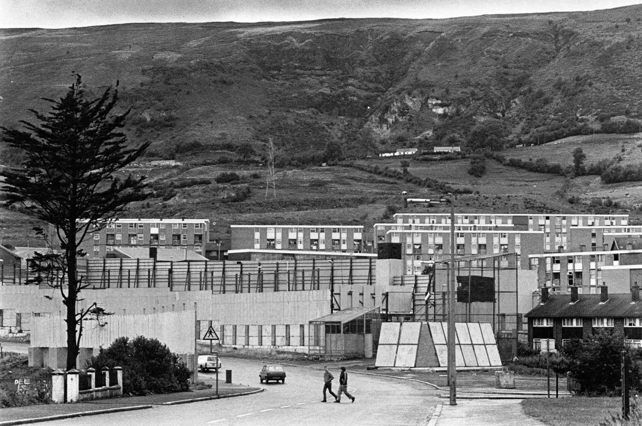
2008 Glenbryn Park
3.1.1 Reference code(s)
UK INT-ARC PA2015 CL12-P0100
3.1.2 Title
Photograph of 'Peacewall' at Glenbryn Park / Alliance Avenue, Belfast, 2008
3.1.3 Cluster
BIP Interface Cluster 09: Crumlin Road / Ardoyne / Glenbryn
3.1.4 Owner
NI Department of Justice
3.1.5 Year built:
1991 & 2003
3.1.6 Type
Steel frame, corrugated metal sheet, steel mesh fence.
3.2.1 Date of description
2017
3.2.2 Level of description
Items
3.2.3 Extent and Medium
Digital Image - 1529 × 1159 pixels JPEG Image
3.2.4 Name of creator(s)
© Peter Maloney
3.2.5 Archival History
Archived on January 24, 2017
3.4.1 Conditions of access
No restrictions on access. Reproduction requires permission.

2003 Glenbryn Park
3.1.1 Reference code(s)
UK INT-ARC PA2015 CL12-P0100
3.1.2 Title
Photograph of 'Peacewall' at Glenbryn Park / Alliance Avenue, Belfast, 2003
3.1.3 Cluster
BIP Interface Cluster 09: Crumlin Road / Ardoyne / Glenbryn
3.1.4 Owner
NI Department of Justice
3.1.5 Year built:
1991 & 2003
3.1.6 Type
Steel frame, corrugated metal sheet, steel mesh fence.
3.2.1 Date of description
2017
3.2.2 Level of description
Items
3.2.3 Extent and Medium
Digital Image - 1529 × 1159 pixels JPEG Image
3.2.4 Name of creator(s)
© Frankie Quinn (http://www.frankiequinn.com)
3.2.5 Archival History
Archived on January 24, 2017
3.4.1 Conditions of access
No restrictions on access. Reproduction requires permission.

2015 Brucevale Park
3.1.1 Reference code(s)
UK INT-ARC PA2015 CL03-P0100
3.1.2 Title
Photograph of removal of Girdwood Perimeter at Brucevale Park, Belfast 2015.
3.1.3 Cluster
BIP Interface Cluster 08: Lower Oldpark - Manor Street
3.1.4 Owner
No longer in existence. Replaced by palisade fencing during the construction of the current Girdwood Community Hub.
3.1.5 Year built:
1978
3.1.6 Type
Steel frame and corrugated metal structures.
3.2.1 Date of description
2017
3.2.2 Level of description
Items
3.2.3 Extent and Medium
Digital Image - 2144 × 1424 pixels JPEG Image
3.2.4 Name of creator(s)
© James O'Leary
3.2.5 Archival History
Archived on January 25, 2017
3.4.1 Conditions of access
No restrictions on access. Reproduction requires permission.

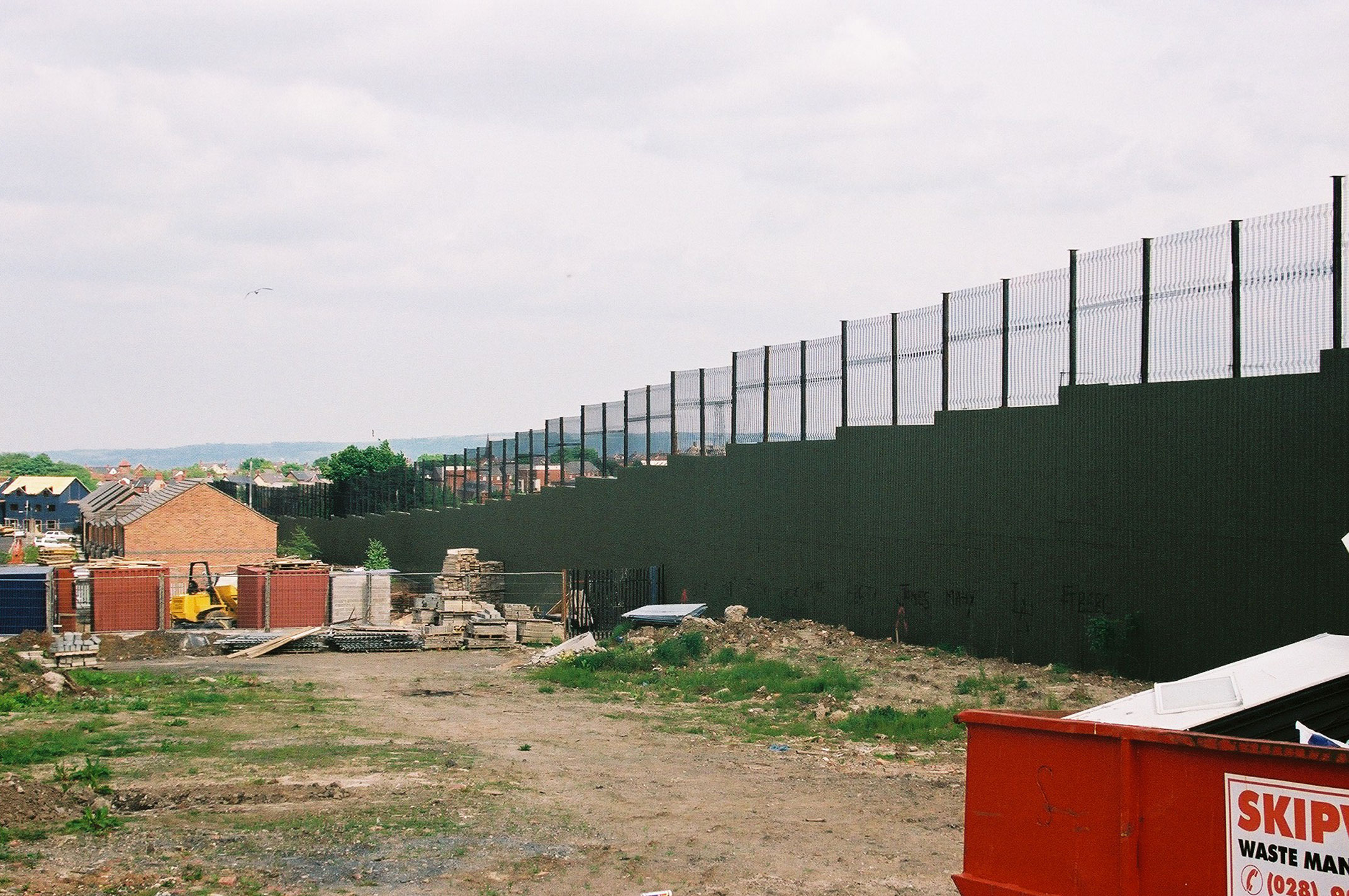
2015 Cliftonpark Avenue
3.1.1 Reference code(s)
UK INT-ARC PA2015 CL08-P0100
3.1.2 Title
Photograph of removal of Girdwood Perimeter at Cliftonpark Avenue, Belfast 2015.
3.1.3 Cluster
BIP Interface Cluster 08: Lower Oldpark - Manor Street
3.1.4 Owner
No longer in existence. Replaced by palisade fencing during the construction of the current Girdwood Community Hub.
3.1.5 Year built:
1978
3.1.6 Type
Brick wall, steel frame and corrugated metal structures.
3.2.1 Date of description
2017
3.2.2 Level of description
Items
3.2.3 Extent and Medium
Digital Image - 2144 × 1424 pixels JPEG Image
3.2.4 Name of creator(s)
© James O'Leary
3.2.5 Archival History
Archived on January 25, 2017
3.4.1 Conditions of access
No restrictions on access. Reproduction requires permission.
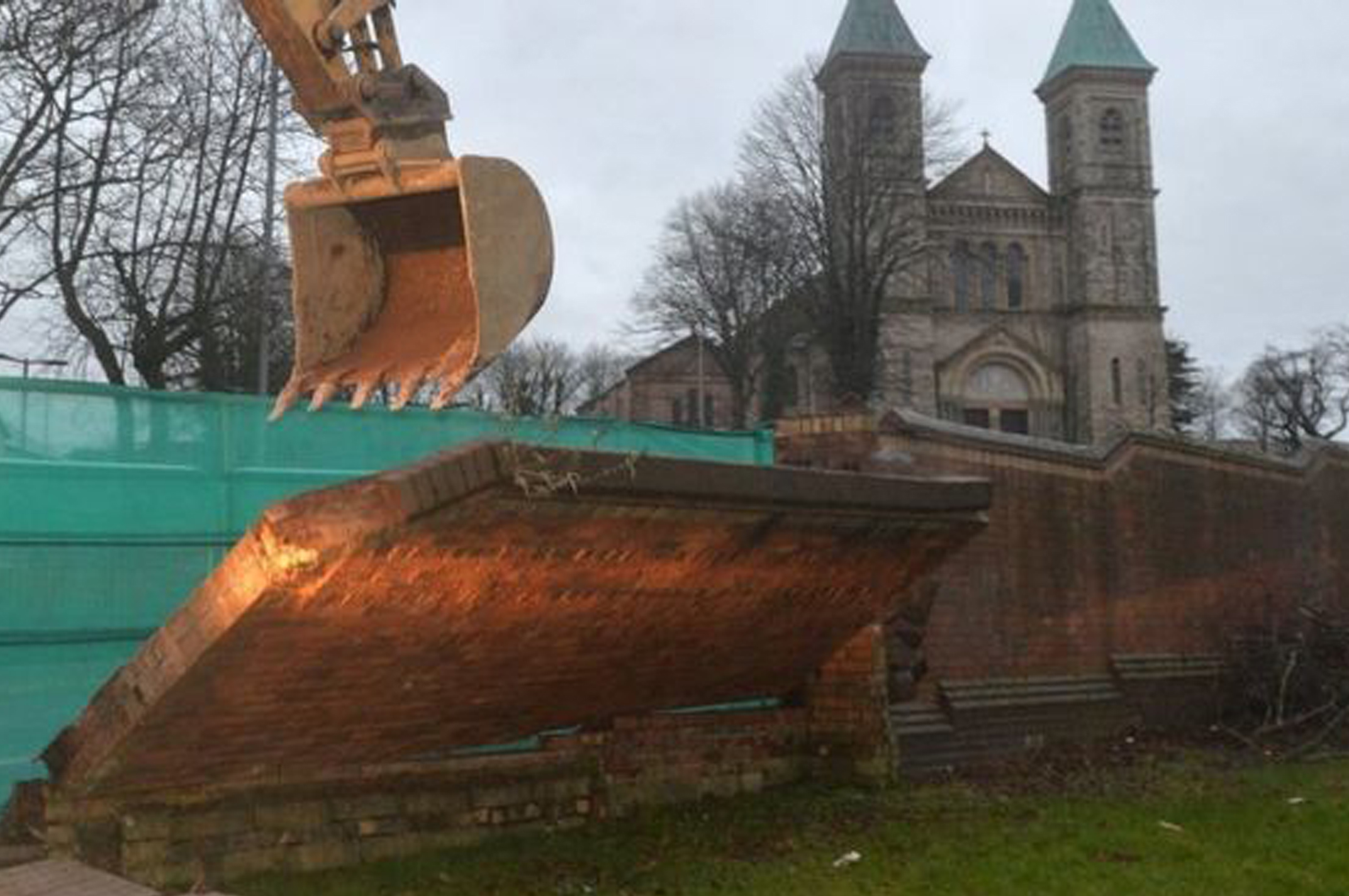
2016 Crumlin Road
3.1.1 Reference code(s)
UK INT-ARC PA2015 CL09-P0100
3.1.2 Title
Photograph of removal of first NIHE-owned 'Peacewall' at Crumlin Road, Belfast, February 25th, 2016
3.1.3 Cluster
BIP Interface Cluster 09: Crumlin Road / Ardoyne / Glenbryn
3.1.4 Owner
NI Housing Executive
3.1.5 Year built:
Unknown
3.1.6 Type
Brick Wall
3.2.1 Date of description
2017
3.2.2 Level of description
Items
3.2.3 Extent and Medium
Digital Image - 1529 × 1159 pixels JPEG Image
3.2.4 Name of creator(s)
© Pacemaker (http://www.bbc.co.uk/news/uk-northern-ireland-35658665)
3.2.5 Archival History
Archived on January 25, 2017
3.4.1 Conditions of access
No restrictions on access. Reproduction requires permission.
History